Some people like a suspenseful, scary story more than they like reality.
Rising seas: 'Florida is about to be wiped off the map' (The Guardian, 2018-06-26)
Coastal areas of Florida may eventually succumb to rising seas...in hundreds of years.
Perspective (and Data) Changes the Story
Check the
NOAA Tides & Currents: Sea Level Trends map to see what local sea level rise is. In Florida it varies between
about 2.1 and
3.7 mm/yr. The variation has a lot to do with
land subsidence. The land in some areas—especially swampy areas or areas where groundwater is being depleted—is subsiding, adding to sea level rise. (In high northern latitudes the reverse is happening. The land is rising;
rebounding from the massive glaciers that used to cover most of it.)
Hal, the geologist in the article frightening the handful of gullible folks who show up to see his dog and pony show, should know this but he probably enjoys the attention he gets from telling scary stories.
If you use an average of 2.7 mm/yr for the 15 stations in Florida it will take 370 years for sea levels to rise 1 meter (3.28 feet). That's not much and adapting to it isn't difficult if you have hundreds of years to adjust. Just ask the Dutch who have been
reclaiming land from the sea for centuries by building dikes and draining the sea.
The story mentions that half the population of Florida lives less than 6 ½ feet (2 meters) above high tide. It will take 740 years for sea level to rise 2 meters. Florida is not "about to be wiped off the map". But the progeny of the current population, 32 generations from now, may have to move inland a little. Unless they do like the Dutch and engineer some practical solutions.
the (IPCC) expects roughly two feet of rise by century's end. And the (NOAA) estimates an upper limit of six and a half feet.
Yeah, but those guesses aren't based on real-world measurements. They're from computer models which are
demonstrably inaccurate. The latest report,
IPCC AR5, was published in 2013. In 87 years, at the current rate (depending on how you measure, by satellite or tide gauge), sea levels will have risen 148 to 278 mm (
5.8 to 11 inches). That's a whole lot less than two feet. Or six and a half feet.
The rate of sea level rise is currently doubling every seven years
No it's not. In fact it appears to be doing the opposite: slowing down. You can see for yourself from the
data collected by NOAA and other research organizations. NOAA and NASA keep decreasing the average rate of sea level rise they publish, from over 3.4 to 3.2 to now 3.1 mm/yr. How did Hysterical Hal come up with "doubling every seven years"?
Look at the University of Colorado's Sea Level Research Group
data on sea level rise. And here are graphs from
NASA's website of sea level rise measured by satellite and tide gauges.
 |
| Sea Level from Satellite Telemetry, 1993–2018. Rate is 3.2 mm/yr. |
 |
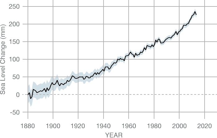
| Sea Level from Tide Gauge Data, 1870–2013. Rate is 1.7 mm/yr. |
The tide gauge data goes back almost 150 years. There appears to be an increase in rate starting about 1930, but only because there was no sea level rise over the prior two decades. The rate since 1930 shows no appreciable increase. The tide gauge graph shows a rate increase after 2000, but the satellite data does not. The discrepancies between the rates measured by tide gauges and satellites has nothing to do with sea level rise itself. It has to do with the accuracy of the instruments and statistical methods used to aggregate the data.
It's All About Context
From 1900 to 2000 the glacier on the screen retreated inward eight miles. From 2001 to 2010 it pulled back nine more; over a single decade the Jakobshavn glacier lost more ice than it had during the previous century.
Sure, but missing important context. Glaciers retreat in response to warming air temperatures. They also retreat due to lack of precipitation (snow), geothermal warming under the glacier, meltwater running under the glacier, and how much of the tongue of the glacier extends into the ocean and the temperature of that water. Jakobshavn is a dramatic example of a glacier losing mass; however there are glaciers in Alaska that have
grown in size (Taku Glacier) while nearby glaciers have retreated, highlighting the fact that
many factors affect glacier mass.
Changes in size (Columbia Glacier) do not necessarily correspond to global temperature changes.
“Greenland is currently calving chunks of ice so massive they produce earthquakes up to six and seven on the Richter scale,” Hal says as the city of ice breaks apart. “There was not much noticeable ice melt before the nineties. But now it accelerates every year, exceeding all predictions. It will likely cause a pulse of meltwater into the oceans.”
A favorite tactic of doomsayers and storytellers: paint an eye-catching visual image to highlight the drama, but leave out the context.
Greenland and Antarctica have been calving massive ice chunks for thousands of years but no one noticed because no one was around to notice. Now we have an increasing number of instruments and survey teams observing these events. The mass of the Greenland ice sheet has been measured regularly by satellite for
only about 20 years now. We don't know how much it gained or lost mass over the preceding decades so we have no basis for making predictions. Ancient trees and forests are being uncovered under receding glaciers in
Europe and
North America. Glaciers in many places had receded more several thousand years ago than they have now; enough that forests thrived. To say ice loss "accelerates every year, exceeding all predictions" isn't a scientific statement. It's hyperbole.
The bottom line, the measurement that matters, is sea level rise. That's what will affect people in Florida and all over the world who live in low-lying coastal areas. Despite all the claims of accelerating ice loss in Greenland and Antarctica,
we don't see the supposedly accelerating ice loss noticeably affecting measurements of sea level rise.
More Context
And speaking of context, it should be no surprise that glaciers have generally decreased in mass globally in recent history because they've been doing so for the last 12,000 years since natural warming started melting the massive,
mile-thick glaciers that covered much of the upper Northern Hemisphere.
If you go back before the previous glacial period to the peak of the prior
interglacial (warm) period 125,000 years ago,
sea level was 4 to 6 meters higher than now (13 to 20 feet). At the current rate, that will take another 1,600 to 2,400 years.
And Even More Context
If you really want some context, sea levels were 120 meters (394 feet) lower about 20,000 years ago at the coldest point of the last glacial period before the earth started warming and the continent-sized glaciers began to melt. The earth has experienced warming and cooling periods several times over the last million years, each lasting roughly 100,000 years with 25° C (45° F) global temperature variations and
sea level changes of 125 meters (410 feet).
Notice that in the last 3 cycles the cold glacial periods lasted much longer than the relatively brief warm periods. We should be ecstatic that we don't live in a glacial period.
No one knows what causes these large-scale climate changes but
Milankovitch Cycles are a leading contender. We live on a remarkable and dynamic planet.